


Post by Falconer on Mar 11, 2020 13:35:35 GMT -5
I’ve been delving into various maps, and here are some initial observations.
Modern Trek calls everything west of Sol “Alpha Quadrant” and everything east of Sol “Beta Quadrant.” There are also Gamma and Delta Quadrants far away to the northwest and northeast. I ran with those assumptions in the following analysis, though I am not sure I will continue to use that nomenclature.
Here I will consider Star Fleet Technical Manual and Star Trek Maps. I have attached simplified (grayscale negatives) and annotated maps. Starting with the SFTM, we get a galaxy map…
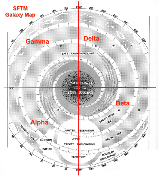
I added the quadrant names in red. So far so good; it looks like Klingons are in the Alpha Quadrant and Romulans in the Beta Quadrant. The next map from SFTM zooms in on the Federation “Exploration Territory”:
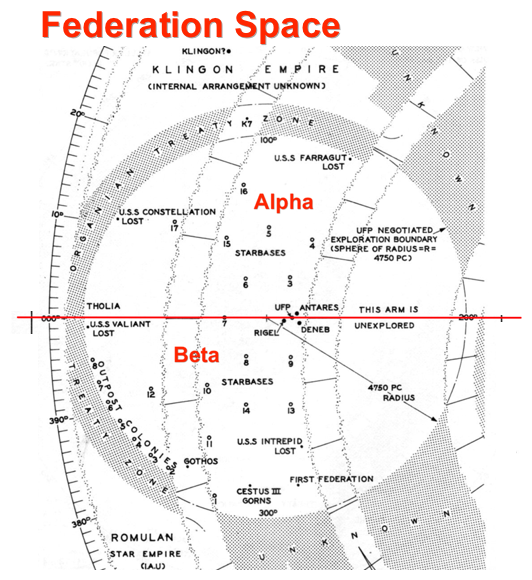
Again, Klingons are west and Romulans are east. Gorns and the First Federation are also to the east; Tholians in the west. Note the UFP proper is a small dot on this map, at the center point of Rigel, Deneb, and Antares. SFTM finally gives as a map of that little dot:
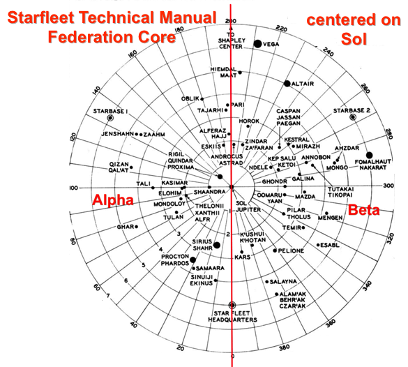
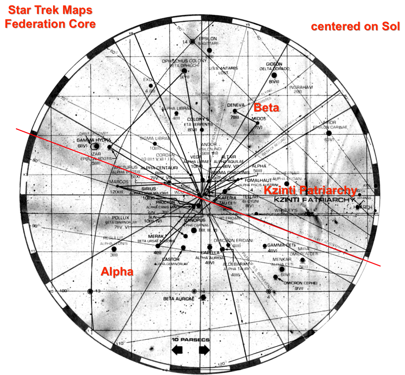
Okay, moving on to STM. STM scales back the ambition of Federation Space to be basically the Rigel-Deneb-Antares region, and then moves all the neighboring empires closer around that:
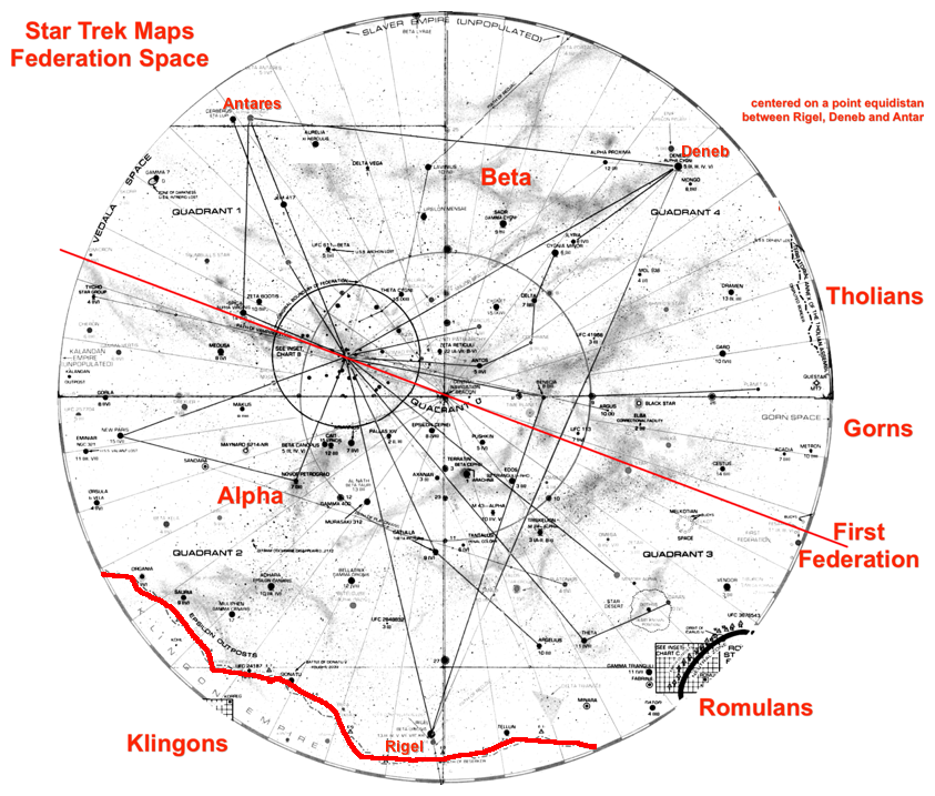
I have drawn the red line through Sol, because that’s supposed to be the dividing point between Alpha and Beta. However, STM doesn’t operate under that assumption at all. The quadrants here are of course the quadrants of Federation space, which is here not centered on Earth. I think, taking this map on its own terms, it is best to still think of Romulans to the east, i.e., in the Beta sector, and Klingons wrapping around the south (mostly west but also having plenty of presence to the east). Note that Gorns and First Federation are swapped, and the Tholians are also moved drastically. STM also has a map of the Enterprise’s area of patrol, which is the southeast corner of the previous map:
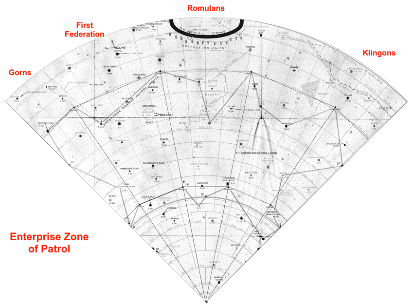
So this basically established that TOS covers the southern half of the (proto-) Beta Quadrant. You can’t really see (I didn’t want to post very high resolution images), but many features that SFTM had had on the west are moved to this southeast area. STM contains many other interesting maps, but of interest is its map of the Federation “original boundary”:
I think STM had a better sense of scale than SFTM, and is all around more useful. Though I think SFU materials more follow SFTM.
Modern Trek calls everything west of Sol “Alpha Quadrant” and everything east of Sol “Beta Quadrant.” There are also Gamma and Delta Quadrants far away to the northwest and northeast. I ran with those assumptions in the following analysis, though I am not sure I will continue to use that nomenclature.
Here I will consider Star Fleet Technical Manual and Star Trek Maps. I have attached simplified (grayscale negatives) and annotated maps. Starting with the SFTM, we get a galaxy map…
I added the quadrant names in red. So far so good; it looks like Klingons are in the Alpha Quadrant and Romulans in the Beta Quadrant. The next map from SFTM zooms in on the Federation “Exploration Territory”:
Again, Klingons are west and Romulans are east. Gorns and the First Federation are also to the east; Tholians in the west. Note the UFP proper is a small dot on this map, at the center point of Rigel, Deneb, and Antares. SFTM finally gives as a map of that little dot:
Okay, moving on to STM. STM scales back the ambition of Federation Space to be basically the Rigel-Deneb-Antares region, and then moves all the neighboring empires closer around that:
I have drawn the red line through Sol, because that’s supposed to be the dividing point between Alpha and Beta. However, STM doesn’t operate under that assumption at all. The quadrants here are of course the quadrants of Federation space, which is here not centered on Earth. I think, taking this map on its own terms, it is best to still think of Romulans to the east, i.e., in the Beta sector, and Klingons wrapping around the south (mostly west but also having plenty of presence to the east). Note that Gorns and First Federation are swapped, and the Tholians are also moved drastically. STM also has a map of the Enterprise’s area of patrol, which is the southeast corner of the previous map:
So this basically established that TOS covers the southern half of the (proto-) Beta Quadrant. You can’t really see (I didn’t want to post very high resolution images), but many features that SFTM had had on the west are moved to this southeast area. STM contains many other interesting maps, but of interest is its map of the Federation “original boundary”:
I think STM had a better sense of scale than SFTM, and is all around more useful. Though I think SFU materials more follow SFTM.

