|
|
Post by Falconer on Jun 18, 2020 13:25:00 GMT -5
I’m working on a “conversion” formula for translating between coordinates from STAR TREK MAPS (1980) and those given in THE FEDERATION (1986) and other FASA products. After a lot of trial and error, I think I’ve got it. They moved many systems, but, the layout is overall similar, so, you can easily port a location from one system to the other. 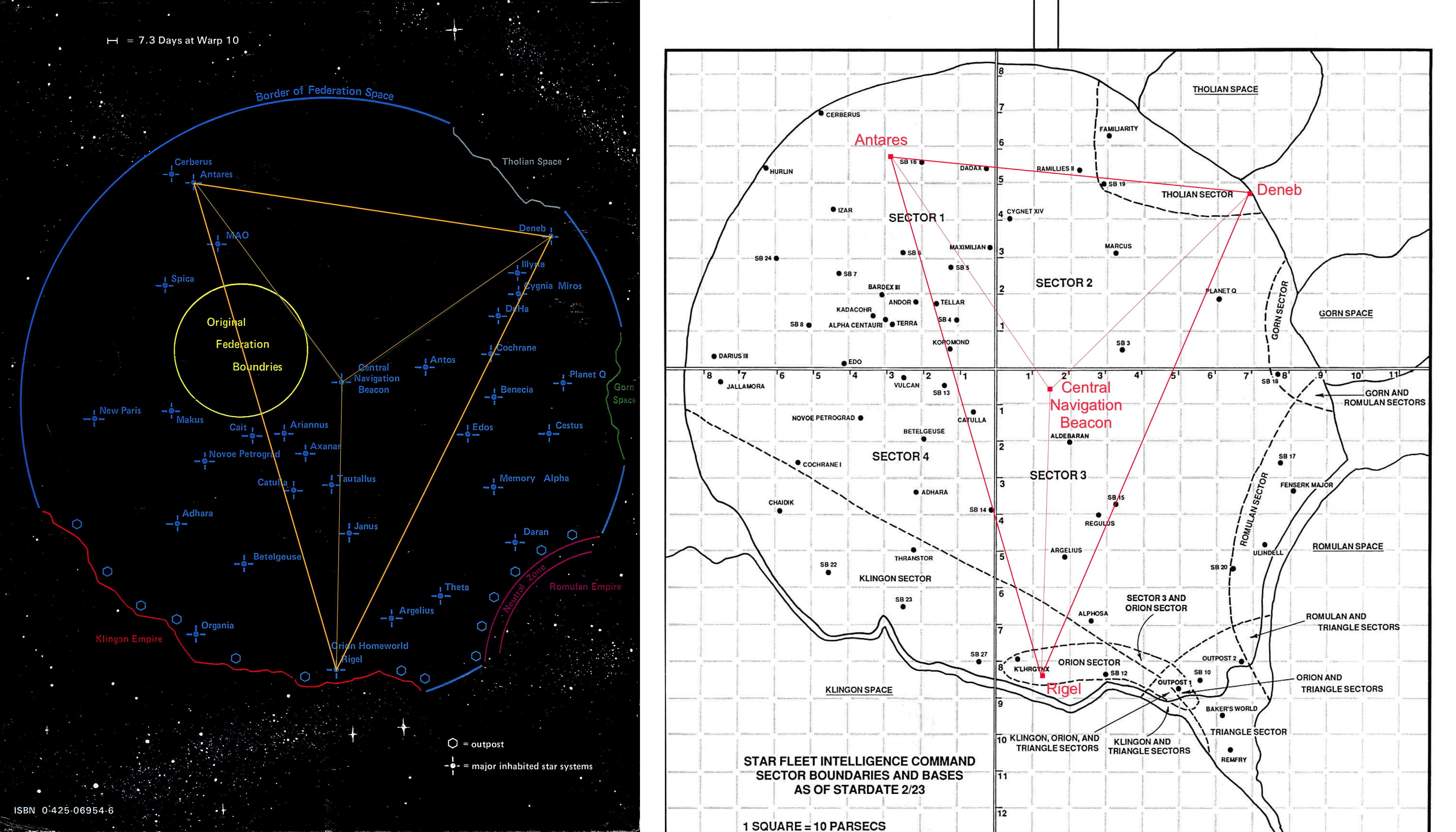 The maps I've used for illustration purposes are from the first edition of TRADER CAPTAINS AND MERCHANT PRINCES (1983) and STAR FLEET INTELLIGENCE MANUAL (1987). Star Trek Maps gives The Federation a stated diameter of 480 parsecs, and FASA gives The Federation a stated diameter 180 parsecs. Star Trek Maps gives its coordinates in parsecs, and FASA gives its coordinates in tens of parsecs. Thus, Star Trek Maps coordinates may be multiplied by 0.0375 to arrive at something that looks like a FASA coordinate. After much trial and error, I decided to use the position of Rigel to determine how much to offset the result. From this, I deduced that 0.639 must be subtracted from North/South coordinates, and 1.559 must be subtracted from East/West coordinates. Per Star Trek Maps, North and West are positive, and South and East are negative. I considered the position of Rigel a critical anchor point due to all the awesome adventuring possibilities in that Southeast region. Final formula: NORTH/SOUTH-COORDINATES: y = 0.0375x - 0.639 x = star trek maps; y = fasa EAST/WEST-COORDINATES: y = 0.0375x - 1.559 x = star trek maps; y = fasa Note that the later FASA system gives different positions for Antares and Deneb. And if there is a “Central Navigation Beacon” in the later system, it would probably be at FASA’s 0.00,0.00 point. I plotted the Star Trek Maps coordinates for these for experimental purposes. And just to be clear, this is all completely unrelated to Star Trek Star Charts (2002). Reverse formula (FASA to STM): NORTH/SOUTH-COORDINATES: x = (y + 0.639) * 80/3 x = star trek maps; y = fasa EAST/WEST-COORDINATES: x = (y + 1.559) * 80/3 x = star trek maps; y = fasa WORLDS OF THE FEDERATION (1989) also uses the same coordinate system as Star Trek Maps. |
|
|
|
Post by Falconer on Jun 18, 2020 13:43:18 GMT -5
After doing this project, I decided to stick with Star Trek Maps as my default map. I am running a lot of FASA modules, but, I have spent a lot of time with STM, and I think it's a really beautiful and well-thought-out product. I like the size and scale, and I really like the placements and the details. Now that I have a conversion formula, it will be trivially easy for me to borrow placements from FASA and plot them onto the STM. I put the stated coordinates from the STM booklet into a spreadsheet as a starting point: docs.google.com/spreadsheets/d/1zvJk9e_bC8uiRU0zI4OrQXHydsaPuKFZ9C_GiF-dxcM/edit?usp=sharingIn the right hand columns you can see I converted the X and Y values from parsecs to light years, since my goal is to create a hex map in the style of STARSHIPS & SPACEMEN (which uses 1 ly diameter hexes). I have no plans to use the Z values at this time. On the second tab you can find some of the coordinates from FASA. Not a lot. I think I will be borrowing them on an ad hoc basis. I will start with the coordinates for the Starbases, since this is one area where FASA is really useful. I will also eventually be including everything from THE TRIANGLE (1985). |
|
|
|
Post by byron on Nov 7, 2020 19:05:09 GMT -5
Interesting stuff! I'd love to see a full map of the FASA Star Trek universe. Unfortunately, all I can find are 3D maps that make it difficult to construct a game map.
|
|
c57d
Lt. Commander

Posts: 169 
|
Post by c57d on Nov 8, 2020 7:56:38 GMT -5
To my knowledge, FASA never published a full map of its setting.
The Federation supplement provided co-ordinates for all UFP systems, so you could get out your graph paper and pens and map a 2D (FASA) version.
I have mapped out the whole thing myself once, and a section of it once. It is very time consuming, but can be done.
My only argument with it is that I disagree with the placement of core systems in relation to the enemy empires.
Core/founding worlds are in the NW quadrant, while Romulan and Orion empires are in the SE.
Now, given that we encountered both some 120+ years before Kirk and then expanded out from there, shouldn't they be closer to the core UFP, and not some 200 parsecs apart?
For my version of the map, I shifted the core systems into the SE to better reflect my opinion.
This left a gap in the NW, which I hand waved away as a gap between stellar arms.
Ymmv.
Unfortunately, other than the Triangle & Orions, FASA never published any more than a handfull of system co-ordinates for Klingon or Romulan space.
|
|
|
|
Post by Falconer on Nov 9, 2020 0:41:02 GMT -5
The Klingons 2nd Ed has a lot of coordinates for Klingon systems.
|
|
TardisCaptain
Lieutenant
Creating a new website for gaming purposes.
Posts: 82
|
Post by TardisCaptain on Nov 10, 2020 0:32:01 GMT -5
The Romulans has a map with the grid. It should be enough to get the systems listed on a master map. Speaking of master map, I had downloaded this from one of my other online FASA resources. I think it was from an old Yahoogroup. Attachments:
|
|
|
|
Post by Falconer on Nov 10, 2020 17:33:23 GMT -5
Cool! Would be nice if we could figure out who made it. Would be neat to get a copy that was larger and didn’t have the grid overlay. Kellri has a Fasa Trek Worlds.pdf on his site which is nice, too. |
|
TardisCaptain
Lieutenant
Creating a new website for gaming purposes.
Posts: 82
|
Post by TardisCaptain on Nov 11, 2020 23:24:02 GMT -5
With the Yahoogroups shutting down, I'll have to hurry and see if anyone can get me a credit for that map.
I also found this while going through my fan-made FASA stuff. This has references from the published material as well as third-party.
|
|
TardisCaptain
Lieutenant
Creating a new website for gaming purposes.
Posts: 82
|
Post by TardisCaptain on Nov 12, 2020 12:53:01 GMT -5
Ok good news bad news.
The good news is I found the name of the map maker. Kevin Oyer. All of his files that he submitted to the old Yahoogroup have been moved over to the new groups.io mailing list.
The bad news, apparently he has passed away. His files were found in a "memorial" section of the files directory.
If you would like the link to the groups.io page, please let me know.
|
|
|
|
Post by Falconer on Nov 12, 2020 22:34:44 GMT -5
Sure
|
|
TardisCaptain
Lieutenant
Creating a new website for gaming purposes.
Posts: 82
|
Post by TardisCaptain on Nov 14, 2020 0:29:41 GMT -5
|
|
|
|
Post by ThrorII on Dec 17, 2020 21:03:34 GMT -5
My only argument with it is that I disagree with the placement of core systems in relation to the enemy empires. Core/founding worlds are in the NW quadrant, while Romulan and Orion empires are in the SE. Now, given that we encountered both some 120+ years before Kirk and then expanded out from there, shouldn't they be closer to the core UFP, and not some 200 parsecs apart? That's the major problem with both ST Maps and the FASA maps. Given that the Earth-Romulan War took place 100+ years before TOS season 1, I'd assume it was fought with Warp 3 ships (maybe Warp 4). The Romulan Empire should be only 25 or so LY from Earth. I could see the Neutral Zone hemming in the RSE with the Federation surrounding it - kind of like how Kirk in BoT stated that the Neutral Zone separates the Planets of Romulus and Remus from the rest of the galaxy. |
|
c57d
Lt. Commander
Posts: 169
|
Post by c57d on Dec 20, 2020 13:16:42 GMT -5
My only argument with it is that I disagree with the placement of core systems in relation to the enemy empires. Core/founding worlds are in the NW quadrant, while Romulan and Orion empires are in the SE. Now, given that we encountered both some 120+ years before Kirk and then expanded out from there, shouldn't they be closer to the core UFP, and not some 200 parsecs apart? That's the major problem with both ST Maps and the FASA maps. Given that the Earth-Romulan War took place 100+ years before TOS season 1, I'd assume it was fought with Warp 3 ships (maybe Warp 4). The Romulan Empire should be only 25 or so LY from Earth. I could see the Neutral Zone hemming in the RSE with the Federation surrounding it - kind of like how Kirk in BoT stated that the Neutral Zone separates the Planets of Romulus and Remus from the rest of the galaxy. I, once, for a FASA Starfleet campaign, drew up the FASA Federation map with the core/founding worlds to the SE quadrant, so forming a loose triangle with both Orion and Romulan space. In that instance I left the RSE as is, but if I ever redrew that I would certainly move the RSE much closer to Terra (your 25 odd LY sounds about right) and hem it in by the Federation on all sides. This ties in with Kirk's line, as you mentioned, but maybe requires some thought to reconcile the Commander/Senior Centurion's conversation about 100 campaigns together. I would prefer to assume that after the failure of the war against Terra, and the frustration of being hemed in by an all encompassing RNZ the Romulans turned their aggression inward in civil war, and these are the 100 campaigns. And the BoT mission is a renewed effort to break out of restrictions and wage war on the humans again!! |
|
|
|
Post by ThrorII on Dec 20, 2020 14:35:52 GMT -5
That's the major problem with both ST Maps and the FASA maps. Given that the Earth-Romulan War took place 100+ years before TOS season 1, I'd assume it was fought with Warp 3 ships (maybe Warp 4). The Romulan Empire should be only 25 or so LY from Earth. I could see the Neutral Zone hemming in the RSE with the Federation surrounding it - kind of like how Kirk in BoT stated that the Neutral Zone separates the Planets of Romulus and Remus from the rest of the galaxy. I, once, for a FASA Starfleet campaign, drew up the FASA Federation map with the core/founding worlds to the SE quadrant, so forming a loose triangle with both Orion and Romulan space. In that instance I left the RSE as is, but if I ever redrew that I would certainly move the RSE much closer to Terra (your 25 odd LY sounds about right) and hem it in by the Federation on all sides. This ties in with Kirk's line, as you mentioned, but maybe requires some thought to reconcile the Commander/Senior Centurion's conversation about 100 campaigns together. I would prefer to assume that after the failure of the war against Terra, and the frustration of being hemed in by an all encompassing RNZ the Romulans turned their aggression inward in civil war, and these are the 100 campaigns. And the BoT mission is a renewed effort to break out of restrictions and wage war on the humans again!! I have a personal reconciliation for the "100 campaigns" line. The BoT map does not show a RNZ encircling just a single system, rather it appears much larger than that.
Based on Kirk's statements and the Sector Map in BoT, I reconcile that at the end of the Romulan War, the RNZ was constructed around a 'zone of influence' for the Romulans. Perhaps Romulan Territory is a sphere 10 to 15 LY across, all surrounded by the RNZ. That would leave 5-10 systems within the zone - some of which are probably inhabited based on Star Trek habitation rates. This RNZ would indeed be 'separated from the rest of the galaxy'.
It is also possible that the Romulans had a civil war - or a series of civil wars - because of their loss to Earth. Those 'campaigns' may have been wars of reunification. That would also help to explain why they were silent for 100 years.
If you wanted to combine this theory with canon Star Trek, possibly the RNZ is acutally an elliptical cone - heading out from the Federation side. That would leave the Romulans room "eastward" to expand.
|
|
|
|
Post by byron on Oct 8, 2021 15:59:00 GMT -5
Not sure if anyone is still working on this but there is an expanded FASA Star Trek map at the following site. It is still in process but it does have a lot of good information on it already. fasaststcs.com/index.php/publications/I'm not sure how the coordinates for the planetary systems would be mapped on a hex map? |
|